FLOODS, DROUGHTS AND STORMS. DRONES IN CAMBODIA HELP TO INFORM PEOPLE ABOUT THE RISK OF DISASTER
Published: Oct 12, 2017 Reading time: 5 minutes Share: Share an articleIn Cambodia, PIN has started using drones for the collection of elevation imagery intended for the production of maps. Drones have enabled the fast and affordable procurement of high quality imagery, and thus have increased the cost-effectiveness of mapping exercises and accelerated the Disaster Risk Reduction efforts of PIN in the country.

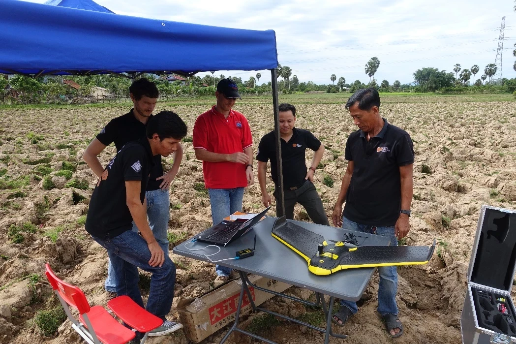
PIN has started using unmanned aerial vehicles (UAVs), commonly known as drones, in Cambodia for mapping purposes. PIN uses a fixed wing drone that, operated remotely by a PIN Geographic Information System officer, collects high-resolution aerial images of a given area. Processed images can be used for spatial analysis and the production of maps useful for the community, local administration and other development actors. Use of drones has significantly reduced the time needed for procurement of up-to-date maps, especially of extensive areas. Produced by the Swiss company senseFly , the drone is equipped with a camera and e-motion software for flight planning and management, data collection, and preprocessing of collected data. Drone collected imagery is compatible with a wide range of industry software, such as pix4D, with which it can be transformed into georeferenced orthomosaic rasters, digital surface models and point clouds. In comparison to heavier drones, this 2 kilogram drone poses a smaller safety threat to people and property in case of emergency landing or crashes. Additionally, its battery allows for longer flights. The use of the drone for mapping purposes was piloted through 2016 internal PINnovations call and its purchase was funded by PIN Club of Friends and EuropeAid.
CONTEXT
Disaster Risk Reduction (DRR) is an important element of PIN operations in Cambodia where recurring cycles of floods, droughts and intensive storms destroy people’s livelihoods and development gains. Since devastating floods in 2011, PIN has been one of the leading international non-governmental organisations in this sector, building temporary evacuation sites and providing drinking water during floods, retrofitting water points to withstand them, designing disaster resistant houses and rolling out a national Early Warning System (EWS). Development of Emergency Preparedness and Response Plans (EPRP) is an important element of DRR support that PIN provides to local authorities. Besides demographic, socio-economic and other data, good satellite or aerial imagery is an essential requirement for preparation of EPRPs. By analysing elevation data, it is possible to identify, depending on the disaster scenario, the most-at-risk areas, evacuation options, at-risk populations, property and infrastructure, and to design appropriate preparedness, mitigation and adaptation measures. If the imagery is of high resolution, it is even possible to estimate the vulnerability of physical structures. However, in Cambodia elevation data is often unavailable or outdated and obtaining up-to-date satellite imagery is very expensive. Moreover, while generally of good quality, satellite imagery tends to be less flexible andoffers fewer details than aerial pictures.
IMPLEMENTATION
PIN Cambodia has been using geographic information systems in its work since 2012. PIN Cambodia has also been closely following the development of UAV technology, especially in humanitarian relief sector. senseFly drones were selected because they best corresponded to the country programme’s needs and were provided with robust technical support from the senseFly team in Switzerland. Prior to using mapping drones, PIN introduced the purpose of the drones and the technology behind them to local authorities. The authorities mistrusted flying objects and associated them with spying activities. It was therefore necessary to take time to explain that drones were harmless and were to be employed to support local authorities and communities. It should be taken into account that there are a few practical limitations to using drones. For one, drones require open areas for taking off and landing which can be sometimes difficult to find in urban settings. For another, drone batteries have low performance. The currently used fixed wing drone can fly with one propeller for 40 minutes and then must return to the take-off location for the battery to be changed so that the drone may continue flying. This can be particularly time consuming when mapping a large area.
ACHIEVEMENT
PIN used UAVs in Cambodia to determine the best sites for the installation of automatic water gauges and for the preparation of elevation maps of surrounding areas. In Cambodia's capital, PIN, in collaboration with local authorities, mapped 35 urban communities using drones. Orthophoto maps of these hazard-prone and impoverished settlements which house thousands of people were used for the preparation of District and Commune Development Plans and the subsequent upgrading of local infrastructure. This ultimately increased access to basic services in the area.
NEXT STEPS
In 2017, drones will continue to be used for the mapping of areas which are at high risk of floods and of Phnom Penh’s poor communities. Drones will be also employed in rural settings, especially in coastal areas, as part of PIN’s expansion of the Early Warning System. Despite significant initial investment, drones quickly recoup these costs, if used extensively. Besides additional mapping drones, PIN Cambodia plans to purchase a base station in the near future. Base stations generate ground control points which can be used for the correction of droneacquired coordinates. If you are interested in more information about use of drones for mapping purposes, contact Piotr Sasin at piotr.sasin@peopleinneed.cz or James Happell at james.happell@peopleinneed.cz.
This article was published in PIN Bulletin INSPIRED.


